The question about the triangle that swallows ships, planes and all the people with them still waits for its answer. So many ships and planes have disappeared and so many disasters have happened in the area between Bermuda, Puerto Rico and Miami, and many theories have appeared as well. From compass variations, gulf streams, rogue waves to human errors and conspiracy theories – anything is possible, but none of them is proved yet. However, it’s still one of the most traveled routes in the world.
Socotra is archipelago the Horn of Africa and Arabic Peninsula, but the main island of Socotra is 95% of the whole landmass, while the rest is just small islands. This place is probably the most alien-looking on Earth. One third of the flora and fauna on this island, administered by Yemen government, can be found only here. The umbrella-shaped “blood tree,” the cucumber tree, giant succulent tree, different kinds of birds, spiders, bats and cats have the only habitat on Socotra.
The well known statues on the Easter Island, the rapa nui, still remain mystery for the researchers. The statues are over 50 feet tall, but no one has a clue who built them, why they built them, how they were brought there, and so on. One of the theories is that a civilization has lived here long time ago, but the people ate everything on the island and either moved somewhere else or were exterminated.
Racetrack Playa in California is well known due to its sailing stones. No one knows how, but the stones there somehow manage to move from their original position, leaving a track behind them. The reasons are still unknown and are subject of research. It is supposed that the winds in the valley are “responsible” for this.
McMurdo Dry Valleys are located on Antarctica but, believe it or not, they lack snow. That makes the area to be a desert, of course the coldest one in the world. However, that’s not the only strange things here. The valleys are “bleeding” from the many geysers, because of the high concentration of iron, making picture of world different than Earth.
Mount Roraima is located on the triple border point between Brazil, Guyana and Venezuela. It is weird because of its shape, but is also mysterious because of the clouds that are always near the peak and the endemic fauna. The tabletop of the mountain, which is the peak actually, is considered as one of the world’s oldest geological formations. It is believed that the plateau was formed by water and winds, but the reason why some species can’t be found anywhere else remain mystery.
The Fly Geyser, near Gerlach, Nevada, is strange because it somehow grows up. It is three meters high at the moment. It is interesting that this geyser is located on private area, so nobody can enjoy it from close. The owner is Bill Spoo, a man who rejects the opportunity to make a fortune from the tourists, and keeps the beautiful view just for himself and the few researchers and photographers who have to schedule a visit weeks before arriving.
Spotted Lake is a saline endorheic alkali lake located northwest of Osoyoos in British Columbia. In the summer, most of the water in the lake evaporates leaving behind all the minerals. Large “spots” on the lake appear and depending on the mineral composition at the time, the spots will be different colors. The spots are made mainly of magnesium sulfate, which crystallizes in the summer. Since in the summer, only the minerals in the lake remain, they harden to form natural “walkways” around and between the spots.
Kauaʻi is the oldest of the main Hawaiian Islands, it is the fourth largest of the main islands. Seaside lava ledges make for otherworldly experiences on this often-overlooked Hawaiian island.
Most people think of Niagara Falls is the largest in the world. Whereas Guaira Falls is the largest in the world with waterfalls volume reached an average of 1.75 million cubic feet per-second. Source Guaira Falls, is located in the frontier of Brazil-Paraguay, is the river Parana. In 1982, the waterfall was built dams Guaira to Itaipu power plant with a dam which is now the second largest dam in the world’s largest power producer after Gorges Dam.
Iceberg B-15 is the largest iceberg in recorded history. The covers 3100 km, making it larger than Jamaica Pulai. Giant iceberg is due to fracture of Ross Ice Shelf in March 2000. Nearly a decade passed, the parts of the iceberg was still not entirely liquid, the biggest part still considered as B-15a, with the vast field reached 1700 km.
The Dead Sea is the famous for its salt content is very high. Don Juan Pond, a lake with the highest salt content in the world. Comparison when just exposed with the sea in general, Don Juan Pond, 18 times saltier than normal seawater, when compared to the Dead Sea, the Don Juan Pond, eight times more salty. Temperatures in the pool was like a general in the Antarctic region, is relatively low, with the lowest point can reach -30 degrees Celsius. But never got frozen like other places in Antarctica.
The 83-42 is believed as the only parcels of land in the north. It was only a “tiny” size of about 35 m, 15 m and height 4 m. The uniqueness of 83-42 was found in 1998, which at the north pole is covered by ice, We can still find some piece of land.
What we do know that Europe has no deserts, but this assumption is wrong. Europe has a unique dune Pyla ie, the length of 3 km, width of 500 m and height of 100 meters. This place is famous for being the place of paragliding activity. Besides the uniqueness of the dunes, which is also amazing is the surrounding scenery from the heights where we could see the sea and forests.
Meteor Crater is a crater formed by meteorite fall. It is located about 43 miles (69 kilometers) east of Flagstaff, near Winslow in the northern Arizona desert of the United States. Meteor Crater was allegedly formed since 50 000 years ago in the Pleistocene era when the local climate became cooler and more moist. At that time there was a vast grassland and forests, inhabited by mammoths wool, mashed giant lemurs, and camels.
People call it ‘the Gate of Hell “because the 70 meter wide crater it out fires continuously since last 35 years. Starting from 1971 in which geologists doing research in the region to look for mine gas. What happened next is a burst of flame from under the hold continuous, even swallowed all their equipment. The geologist was no one dared to go down into the crater as it was poisonous. You can see it on Google with coordinates 40 ° 15’8 “N 5.
The strange and weirdly beautiful terraced pools of Pamukkale have been appreciated for over two millennia and yet still remain a little known wonder of the world. Thousands of years ago earthquakes, which are common in Turkey, created fractures that allowed powerful hot springs to bring water rich in calcium carbonate to the surface. As the water evaporated the chalky material condensed and formed layer-upon-layer of Travertine and thus slowly built up the walls over time in the same way that a stalactite forms in a cave. Apparently Pammakale means Castle of Cotton but the Greco-Romans built a town above it called Heirapolis – meaning “Holy City” or “Sacred City”. They too recognised it as a rare and important place attributing healing powers to the milky-white waters.
These large, spherical, alien and strangely beautiful boulders are mainly located on Koekohe Beach, part of the Otago coast of New Zealand’s South Island. Known as “Moeraki Boulders” they were originally formed on the sea floor from sedimentary deposits that accreted around a core in the same way that a pearl will form around a particle of sand. The erosion of the cliffs often reveals these boulders from the surrounding mudstone allowing them to join those already on the beach. Some of the larger boulders weigh several tonnes and can be up to three metres wide.Maori legend attributes their origin to the arrival of the first ancestors / giants who came in the great Araiteuru canoe which was sunk by three great waves at nearby Matakaea. .
Found on both land and in the ocean throughout the Bahamas and the national waters of Belize are deep circular cavities known as Blue Holes which are often the entrances to cave networks, some of them up to 14 kilometres in length. Divers have reported a vast number of aquatic creatures some of which are still new to science. In addition, they’ve recorded chambers filled with stalactites and stalagmites which only form in dry caves. For the explorers this was proof that at one time, nearly 65,000 years ago, when the world was in the grip of the last major ice age, the sea level of the Bahamas was up to 150 metres lower than it is today. Over time the limestone of the islands was eroded by water and vast cave networks created. When sea levels rose again about 10,000 years ago some of these collapsed inwards and the Blue Holes were formed.
From space this mysterious depression in the Sahara Desert of Mauritania really does look like a human eye. The image to the left is the "pupil" but a visit to Google Earth zoomed out a little will reveal the cliffs that make up the rest of the eye. This natural phenomenon is actually a richat structure caused by the dome shaped symmetrical uplifting of underlying geology now made visible by millennia of erosion. Please note that this explanation is not wholly accepted by the scientific community. There still remain academics that believe it is the sight of a meteor impact and yet others still that believe it resembles the formations caused by underground nuclear blasts. By the way, we estimate that the detonation would have had to be in the gigaton range. Currently no country in the world has a weapon even close to this destructive yield.
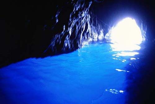
The Blue Grotto sea cave off the coast of the Island of Capri is a natural cave structure with crystal clear blue water that is so amazing you will feel as though you are actually in paradise. The blue reflection is caused by sunlight that passes through a cavity underwater and accentuates the waters color.
The Dead Sea is a salt lake between the West Bank/Palestine/Israel to the west and Jordan to the east. It is the saltiest sea on the planet which contains no animal or plant life (hence the dead) but an amazing sight to be seen.
Blessed with unusual but splendid rock formations, Arizona seems to be the home of natural wonders. The Grand Canyon, the Petrified Forest, the Wave are some of the world’s most visited and photographed places. The Antelope Canyon is split into the Upper Antelope Canyon (Tse’ bighanilini) & the Lower Antelope Canyon (Hasdestwazi). The meaning of their Navajo names translates into “the place where water runs through rocks, respectively “spiral rock arches”. The lower section is deeper, longer and more challenging than the upper one.
The number three spot goes to the hottest inhabited place on earth. If the average year-round temperature in Ethiopia is 94 degrees Fahrenheit, the temperature regularly exceeds 115 degrees in the Danakil Depression, where the Dallol volcano is located.
At approximately 157 feet /48 m below sea level, Dallol is the planet’s lowest land volcano.
The bizarre landscape with hues of red, green, yellow and white consists of salt ponds, hot mineral springs and geysers. The diverse colors come from potassium salts colored by sulphur and various.
The main attraction of Turkey’s Cappadocia region is the Göreme National Park located in the Göreme Valley. Entirely sculpted by erosion, this spectacular landscape hides a wonderful historical heritage. Part of the national park includes rock-hewn sanctuaries that contain unique evidence of Byzantine art from the post-Iconoclastic era, ancient underground cave dwellings and troglodyte villages. There have been discovered the remains of a human habitat estimated to date back to the 4th century.
According to geologists, the eroded plateau of the Turkish valley is an extraordinary example “of the effects of differential erosion of the volcanic tuff sediments by wind and water.”
The South China Karst region extends over 500.000 square kilometers. The spectacular karst topography comprises three provinces: Guangxi, Yunnan and Guizhou.
The Naigu Stone Forest and and the Suogeyi Village are protected UNESCO Sites since 2007. According to Unesco.org, the stone forests of Shilin, Yunnan Province “represent one of the world’s most spectacular examples of humid tropical to subtropical karst landscapes. The stone forests of Shilin are considered superlative natural phenomena and a world reference with a wider range of pinnacle shapes than other karst landscapes with pinnacles, and a higher diversity of shapes and changing colors.”
More than 1,770 perfectly cone-shaped hills can be found in the Central Visayas region of the Philippines, more exactly in Bohol. Unfortunately, these amazing hills aren’t really made of chocolate, but they do look curious. The hills look like a sea of chocolate kisses during the dry season. The unusual geological formation has baffled geologists for decades. There are different theories on how the conical hills formed.
Spread over an area of 50 square kilometers, the amazing hills are Philippines’s 3rd National Geological Monument together with Hundred Islands National Park and Taal Volcano, the world’s smallest active volcano.
The Naga fireballs of the Mekong river are not a question of ‘If’, but a question of ‘What’. They are one of the most well documented unexplained phenomena in the entire world. Every year during October on the night of Wan Awk Pansa thousands of spectators gather on the banks of the Mekong river in Thailand and Laos to see the legendary Naga breathe forth balls of fire from the river itself. Many have been watching this every year for their entire life. The balls themselves are reddish in color and are about the size of an egg. They slowly and silently rise from the river before accelerating high into the air where they disappear. There can be anywhere from tens to thousands of these glowing orbs per night. The balls themselves are seen either side of the festival night, which attests to the fact it’s more than likely of natural origin rather than an organized display by officials.
Their supernatural origin is not without opposition. Manas Kanoksin, a doctor from Nong Khai strongly believes that fermenting sediment on the river’s bottom causes pockets of methane gas to form, and that the Earth’s position in relation to the sun during those days of the year causes them to rise, then spontaneously ignite in the presence of ionized oxygen. Italian chemists Luigi Garlaschelli and Paolo Boschetti, have replicated the lights by adding chemicals to the gases formed by rotting compounds. But other researchers dismiss this theory, pointing out that the rocky river bottom doesn’t have much sediment, and that the water’s turbulence would break up any such methane bubbles before they reached the water’s surface. Whatever the cause, the Naga fireballs of the Mekong are one of the least known, most spectacular of phenomena to observe.
The ancient Indus Valley people, India’s oldest known civilization had a culture that stretched from Western India to Afghanistan and a populace of over 5 million. le—India’s oldest known civilization—were an impressive and apparently sanitary bronze-age bunch. The scale of their baffling and abrupt collapse rivals that of the great Mayan decline. They were a hygienically advanced culture with a highly sophisticated sewage drainage system, and immaculately constructed baths. There is to date no archaeological evidence of armies, slaves, conflicts, or other aspects of ancient societies. No one knows where this civilization went.


No comments:
Post a Comment